Flighttracker: Difference between revisions
Jump to navigation
Jump to search
No edit summary |
|||
| Line 4: | Line 4: | ||
|Picture=flighttracker1.png | |Picture=flighttracker1.png | ||
|Status=In progress | |Status=In progress | ||
|Contact= | |Contact=jelly | ||
}} | }} | ||
| Line 18: | Line 18: | ||
'''Note:''' On Arch use the dump1090-git package from the AUR | '''Note:''' On Arch use the dump1090-git package from the AUR | ||
Yet another fork of [https://github.com/tedsluis/dump1090 dump1090] has range support and can identify the origin of the aircraft. | |||
== Running == | == Running == | ||
Revision as of 10:12, 5 June 2017
| Project Flighttracker | |
|---|---|
| Revplane tracker | |
| Status | In progress |
| Contact | jelly |
| Last Update | 2017-06-05 |
RevFlight tracker
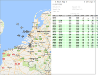
With a simple RTL-SDR it's possible to receive flight "beacons" which a commercial aircraft emits. There is software which in combination with an DVB-t receiver can show the planes flying in the area.
Setup
- Connect your DVB-T receiver
- git clone git@github.com:MalcolmRobb/dump1090.git
- Run `make` (note that you need to have rtl-sdr installed)
Note: On Arch use the dump1090-git package from the AUR
Yet another fork of dump1090 has range support and can identify the origin of the aircraft.
Running
- Run ./dump1090 --interactive --net
- Open http://localhost:8080/ in your browser to see an interactive google map
Images

